


Access flood zone, tax, parcel and PID data with Courthouse Retrieval System (CRS) Data.
CRS Data is the primary tax system used by GAAR and is available for all Flexmls users. This system includes tax and parcel information for the five counties served in the greater Albuquerque market (Bernalillo, Sandoval, Torrance, Valencia, and Santa Fe).
Take a look at the examples below to see what's available to you on a CRS property report.
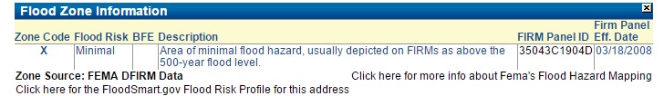
Flood Zone Information – Flood zone data linked from FEMA is available on each CRS property report, including map layers to highlight the different flood plain maps in the area you are searching. Flood zone information is located at the very bottom of the CRS property reports.
PID Information – CRS currently identifies PID information for the three PIDs in Sandoval County (Cabezon, Mariposa East, and Stonegate). Bernalillo County PID data is expected to be added in the upcoming months. PID information in CRS is located in the Tax Assessment section by clicking the link that says 'Click here to see Tax Details'.
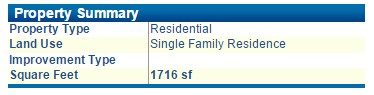
Square Footage – CRS currently identifies square footage of a dwelling for some homes located in Bernalillo, Valencia, and Sandoval Counties. SWMLS advises its REALTOR® members not to use this square footage value on MLS listings.
Comments